Discover the Tuolumne River Beyond the Rapids
Posted July 3, 2024 by Lenka Bostian
The whitewater community recognizes the Tuolumne as California’s premier river rafting destination. Between the Class 4+ Main Tuolumne section and the Class 5 Cherry Creek / Upper Tuolumne section, this Wild and Scenic river offers a whopping 27 miles of heart-pounding rapids. Maybe you’ve experienced the thrill of Clavey Falls rapid or perhaps marveled at the guides’ skill when they were lining the rafts down Lumsden Falls portage. But do you know much about where the river you rafted on originates and where it continues past the take-out spot? Let’s find out!
Mount Lyell and Mount Dana Origins
The source of the Tuolumne River lies in Yosemite National Park’s high country. The western slopes of the 13,000ft Mount Dana drain into a creek heading west, forming the Dana Fork of the Tuolumne. The Lyell Fork originates at one of California’s last surviving (and sadly, disappearing) glaciers, the Lyell Glacier on the north side of Yosemite’s highest mountain – Mount Lyell.
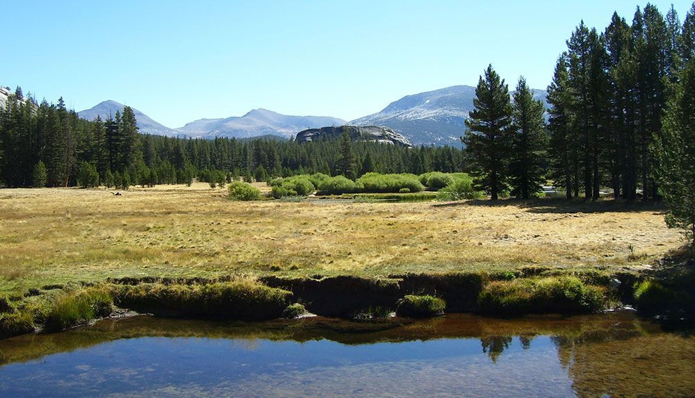
Tuolumne Meadows
Eventually, the two forks meet at the elevation of 8,600 ft, near the Tuolumne Meadows campground* and visitors center. Here you can experience hiking along the famous John Muir Trail which overlaps the even more famous Pacific Crest Trail at this location. The Lyell Canyon hike will take you along the river, through meadows and forests offering breathtaking views and perhaps some glimpses of wildlife. Experienced backpackers can venture further afield with many wonderful options to choose from. Hiking in Tuolumne Meadows, a less visited area of Yosemite National Park, offers a true hikers’ paradise.
*View current conditions of the Tuolumne Meadows campground.
Grand Canyon of the Tuolumne
The Tuolumne meanders lazily through the meadows until it reaches the Grand Canyon of the Tuolumne River. Slow flow is replaced by cascades and waterfalls, with the river dropping in elevation quickly. Tall granite cliffs and solid bedrock riverbed create picturesque sights few people get to admire as this area is deep in the Yosemite wilderness. The lively flow of the river stops at the O’Shaughnessy Dam, forming the Hetch Hetchy Reservoir.
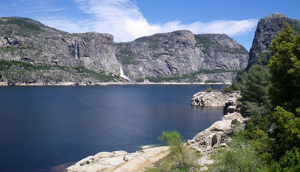
Hetch Hetchy Reservoir
After the devastating 1906 earthquake and fires, San Francisco argued its need for a reliable water source. The city leaders found the solution in the pristine waters of the Tuolumne River and the dam-friendly shape of the Hetch Hetchy Valley, located 167 miles to the east. The glacially carved valley was inhabited seasonally by Native Americans for thousands of years, and its beauty rivaled that of its more popular neighbor to the south – the Yosemite Valley. Controversial even in its own time, the damming of the Tuolumne River inside Yosemite National Park was authorized by the Congress in 1913 and water was first delivered to San Francisco in 1934. Today, the Hetch Hetchy Reservoir area makes for an excellent side trip before or after your Cherry Creek or Tuolumne River rafting trip.
Regulated flows allow for a long rafting season
Much of the Tuolumne water is diverted from the Hetch Hetchy Reservoir through a series of underground tunnels and pipelines. Carefully managed amounts of water are released into the original river channel below the dam. Further downstream, more water is added from Lake Eleanor and Cherry Lake. These two reservoirs are also part of the Hetch Hetchy Water and Power system, which manages water storage and delivery for the City of San Francisco and several other Bay Area cities. Rafters and kayakers benefit from regulated water releases that allow the whitewater season to run from spring through Labor Day in September.
Cherry Creek / Upper Tuolumne rafting
The first commercially rafted section below the reservoirs is called Cherry Creek / Upper Tuolumne. There are only two outfitters permitted to take guests down this very special stretch of whitewater, and All-Outdoors is one of them. Although we put in our rafts on Cherry Creek, this tributary quickly merges with the Tuolumne River, and all the world-famous Class 5 rapids of “Cherry Creek” are actually located on the Upper Tuolumne. This advanced whitewater is not for the faint of heart (many consider it the most difficult commercially rafted river in the US), yet it is more accessible than most people think. All-Outdoors guides prepare for years before they get to lead guests down this thrilling and iconic stretch of a river.
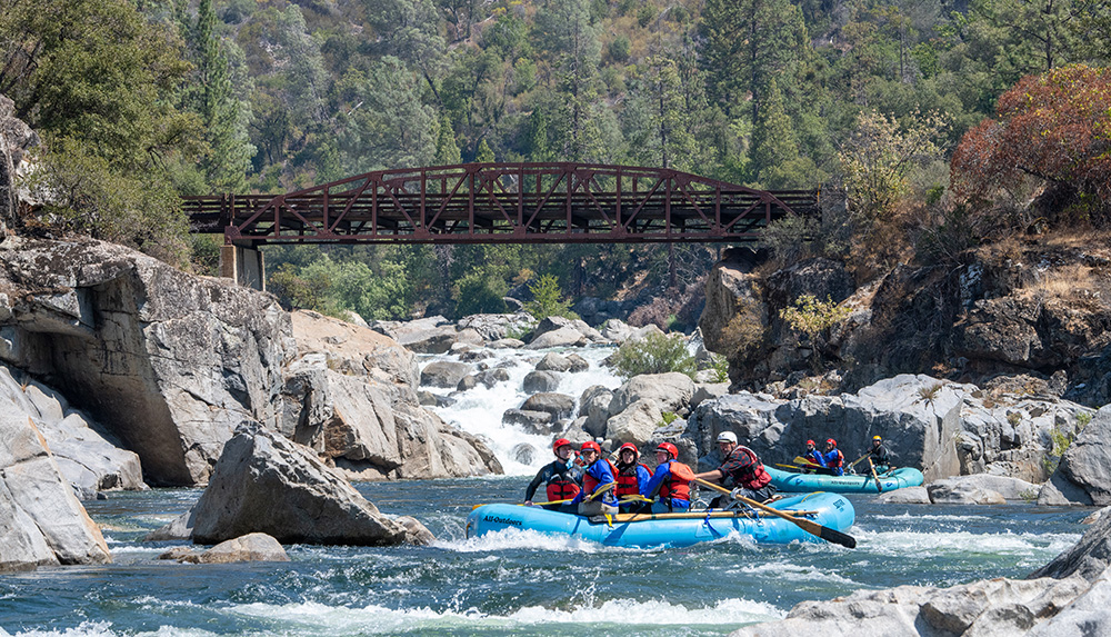
Champagne of California whitewater
Shortly after the aforementioned Lumsden Falls portage, the Merals Pool river access serves both as the take-out spot for Cherry Creek, as well as the starting point for the Class 4+ Main Tuolumne River trips. The 18-mile stretch of continuous whitewater through a remote canyon offers one of the best wilderness rafting vacations in California. It can be done in a single day, but a 2-Day or a 3-Day trip offer an entirely different and wholesome experience. No wonder our overnight rafting trips are so sought-after and popular!
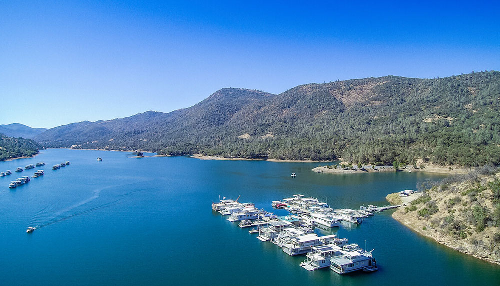
Lake Don Pedro
The graffiti-covered Wards Ferry bridge jostles rafters back to reality as their journey through the gorgeous, remote canyon ends here. The river flow slows down and then stops as the Tuolumne arrives at Lake Don Pedro, the 6th largest reservoir in California.
The stored water is mainly used for agricultural irrigation in the Central Valley, but Don Pedro Reservoir also offers recreational activities. Two marinas allow visitors to launch their own boats, or rent various types of watercraft to enjoy on the expansive lake. This includes motorized as well as self-propelled varieties for those who want to keep their paddling skills sharp. There are three established campgrounds along the lake: Fleming Meadows and Blue Oaks on the west shore, and Moccasin Point, which is closer to the meet place for our Tuolumne and Cherry Creek rafting trips. The Don Pedro Recreation Agency even allows dispersed area camping along the 160 miles of shoreline.
California’s Newest State Park
The limited amount of water that is released below the Don Pedro Dam slowly snakes its way through the flat fertile lands of the Central Valley. At last, the Tuolumne River ends at the confluence with the San Joaquin River west of Modesto. This area is the location of California’s newest state park – the Dos Rios Ranch Preserve. Opened in 2024, this former ranch land has been restored into a floodplain and an open space for Central California residents and visitors to hike in and picnic. At this time the public is invited to help shape future activities that may be offered in this new park, such as camping, fishing, and boating.
Exploring the Tuolumne River reveals a journey far beyond the thrill of rapids. From its origins in Yosemite’s high country to the placid waters of Lake Don Pedro and finally, to the Dos Rios confluence, the Tuolumne offers diverse adventures and natural beauty. Whether you’re rafting down its wild stretches or recreating in another form along its banks, the Tuolumne River invites you to discover its many wonders.
Lenka Bostian
Lenka started working for All-Outdoors in the summer of 2005 when she followed her heart from her native Czech Republic out to California. After graduating college in Prague, she packed up her degree in International Business and moved across the pond for good. She’s been part of the AO family ever since, wearing different hats along the way. Besides trail running, tennis, and traveling, Lenka enjoys rafting and camping on the South Fork with her hubby (former AO guide) and their twin boys.